|
|
| Photo Tours, Travelogues, And Random Topics |
A Photo Tour Of The
Savanna Army Proving Grounds
The US Army’s Version Of Area 51
| Introduction |
The US Army set up the Savanna Proving Grounds
during WWI, with construction starting in 1917. It was originally a remote
site for the Rock Island Arsenal to test cannons. A multitude of unexploded
shells remain in the area as a result.
The Savanna name is easy to confuse with the Department of Energy Savannah
River Site in South Carolina. That confusion worked in the favor of the
Army as the Savanna site became the home for US Army nuclear weapons
projects. Over time, the Savanna installation became a super-secret
development and testing lab where the US Army went when it wanted to
be alone, much like the Air Force’s Area 51.
Note—click on each photo to see the full size image.
|
 |
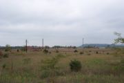
The Savanna site is 14 miles long by 3 miles wide. It adjoins the
Mississippi River, and has a major rail line running through the
property. The location is out in the middle of nowhere on back
country roads.
While water access was key in the location of the Savanna site,
there appear to be little in the form of dock facilities. One
formerly secret dock is located in the maze of islands on the north
end of the installation. That was likely used for commando training
with backpack-sized nuclear weapons.
There are rumors that entire barges can enter man-made caverns
on the side of the river bluffs where they can be unloaded inside
and away from the eyes of Soviet satellites. While that might
be unlikely, it is very possible that underground conveyor belts
were used to move materials from the docks to various construction
sites. As it stands now, there appear to be no roads that run
from the river front to the industrial buildings, which means that
the materials had to be moved underground.
|
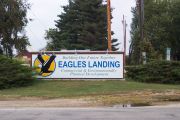 |
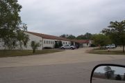
This is the former entrance sign for the Savanna site when it was known
as the Savanna Army Depot prior to being placed on the BRAC list in
1995 and being shutdown in 2000. This sign is located on Illinois Route
84 about 8 miles north of Savanna, Illinois.
The site is currently in the hands of a private company that was set up
by the base closing commission. They have tried a number of ideas to
reuse this facility, but almost nothing has come of it yet. This sign
once read Eagles Landing Retirement Community when they hoped the old
base housing could be converted into condos for retired people. I
guess retired people don’t like living at atomic bomb dumps anymore than
the rest of us.
|
 |
This is a telephone junction box located
outside of the installation. This is some pretty serious telephone
capacity for being a rural area, another clue that something out of
the ordinary was going on nearby. This is just the non-hardened
phone lines. Reports are that buried hardened lines come into Savanna
from a number of DOD locations. In fact, it was recently revealed that
a huge underground data center is located on the Savanna site that once
was a major hub for military communications. A company recently
proposed reusing this underground data center for large companies to
host bomb-proof computer systems. Unfortunately, this idea went belly
up with the dot-com crash. Note—as of 2007, the data bunker concept
is back, and is now up and running at Savanna. A network operations center
has been set up, and you can now house your servers in a bunker that
once was a home to an atomic bomb.
|
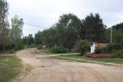 |
This is an off-base housing area. The base
road once ran next to that small building. That building served as a
guard house for the community. A few diehards still live in the settlement.
|
 |
A photo of the old base road, which runs next
to a below the current base entrance road. Note the utility access cover
that goes into an underground conduit. This underground conduit houses
hardened communications lines, plus sewer and water for the locals. The
ground water is so polluted in this area that public sewer and water is
provided for the local area residents.
|
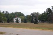 |
Here are examples of base housing. These
are apartment style buildings, likely used by officers given the location
near the HQ building complex.
The Savanna site is reported to have had 800 people between the military
and workers in the munitions factories. While I was not able to tour
the entire facility (I had to keep ducking security guards), I did
not see housing for these kinds of numbers. There is also a report
that as many as 800 more workers were off the record and working on
black projects.
|
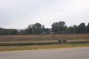 |
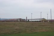
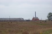
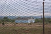
This shot is an overview of one of the
factory complexes. Look carefully through the trees, and you will
realize the magnitude of the size of these buildings. The complex is
well over 1/2 mile long. Since it was off-limits, I was not able to get
any closer.
|
 |
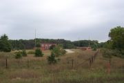
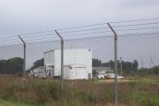
This is the main entry point to the Savanna
site. It is no longer guarded, and it is open to the general public.
There are two public sites within the now closed facility, including a
wildlife viewing platform.
A truck is visible in the background. When I visited, there was a
steady stream of truck traffic in and out of the site. Most of the trucks
were unmarked white cargo vans or semi-tractors. They did not have either
owners name or ICC markings. Since the contaminated soil is being
burned on-site, one can only wonder what is being hauled out in these
trucks. One report is that they are hauling equipment to the McAllister
Army Ammunition Planet in Oklahoma. I find it hard to believe that
equipment that has been sitting for 10 years is still of use. It is
far more likely that they are hauling out soil and materials that are
contaminated with nuclear waste, and taking them to a site in Nevada
for storage.
Ironically, the McAllister plant is located in the city of Savanna,
Oklahoma, further complicating the name game.
|
 |
This is one of the newer buildings on the
site, and it appears that it has been refurbished. Given the number of
pick-up trucks in the parking lot and going in and out of the parking
lot, I suspect that this building houses the engineering office for
the firm that is doing the clean-up work. These big expensive pickups
would likely be assigned to supervisors and site engineers.
Note the reflection in the mirror at the bottom of the photo. The
reflection gives a view of one of the warehouse complexes. We will
see in more detail later on.
|
 |
This is an example of one of the older
warehouse complexes. There are several rows of these metal buildings,
and several buildings in a row. There are perhaps 25 such buildings in
this cluster, with each one being perhaps 100 feet wide by 300 feet long.
These buildings do not have dock facilities and few doors or windows.
The buildings also do not look heated given very little power going in,
and the one chimney looks like it only heats a small office area.
The stuff stored here was not climate controlled, rather, all the buildings
did is keep them dry. That is likely used for storing artillery pieces
and parts of such guns awaiting assembly. It might also be for empty
bomb and shell casings.
|
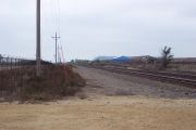 |
This is the mainline of the railroad. It
cuts through part of the base, dividing it into two secured units. That
allowed the railroad to operate through the base without allowing railroad
personal to have access to the base.
|
 |
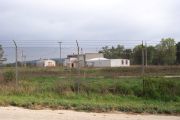
This is a very modern warehouse complex.
Given there are only a few buildings, and the closest building has a
large chiller for a refrigerator/freezer, I suspect that this was the
central stores area for base food and supplies.
|
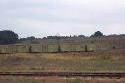 |
There are over 100 miles of US Army rail
road track within the Savanna site. Some of these sidings and spurs are
being used to store box cars. These particular box cars have US Army
markings on them. They were likely used to haul large guns, gun parts,
and specialty bombs out of the Savanna complex, and bring raw materials
in.
|
 |
Here is another complex of the older metal
warehouses. One building is falling apart. It appears that someone
started to dismantle the building, perhaps far enough to allow heavy
equipment into the building. A large pile of contaminated soil in
the foreground likely came from that building. Two of the biggest
contaminants are asbestos and TNT. It is likely that these buildings
are saturated with these hazardous materials.
|
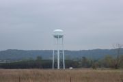 |
A view of the water tower. It appears to have
been recently painted. I am surprised that this much water storage is
needed given that the river is next to the site and wells are easy to dig
in this area. This gives an indication as to how bad the ground water
pollution must be since this water tower obviously serves a fairly large
area of population.
|
 |
This is one of the factory areas. Notice
that the buildings are all connected with covered passages. Also notice
the large hump just before the taller building. That is an entrance to
an underground bunker for storing live ammunition.
|
 |
Here is another factory complex. Again,
notice the covered passage ways radiating out from the central buildings.
Since this is a newer and more up to date building, it was likely used
for R&D and production of depleted uranium rounds for the A-10 tank
killer.
|
 |
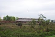
Here is a group of warehouses with railroad
access. There are several rows of buildings, and each row is upwards of
a mile long. Rail tracks run on each side of the buildings. There must
be over a thousand dock doors. Whatever the Army was storing here, they
were storing a lot of it. The scale of this is hard to comprehend...the
buildings go on and on, and there are several such clusters of buildings.
|
 |
Another group of rail cars in storage.
These cars have civilian markings. There was a business planning to
move into the site that repairs rail cars. One has to wonder if these
cars were spotted here for future repair, or if they will be used to
haul stuff out of the plant.
|
 |
While it is hard to see in this photo,
this area is littered with underground bunkers. There is one sticking
up next to the bigger of the two utility poles. The back of a bunker
is sticking up just to the right of this bunker. Another bunker mound
is visible on the very far left hand side of the photo.
|
 |
Two older brick buildings. The closer
building looks like power plant, but with the smoke stack removed.
The more distant building could be a warehouse.
Then again, notice that there are big lightning rods located around
the building. It is possible that these are research labs, especially
given their isolation from other buildings and complexes.
|
 |
There were a number of these odd buildings
on the site. It looks like loads of materials were brought in under
the dock area, then lifted up to the dock to be fed into the manufacturing
equipment. Given the size of the structure, it might have been used for
moving large steel items, such as cannons or bomb casings.
|
 |
More storage units. It looks like these
use a modular plan, and the 2nd building is two units of the first
closer building. Given that these are concrete buildings, it is very
possible that they were used as holding areas for nuclear weapons or
depleted uranium shells.
|
 |
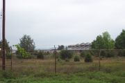
Another view of the newer factory shown
a few photos above. This is a warehouse building with rail access.
The building itself is nearly 1000 feet long, and it connects to the
main factory complex by a series of covered walkways.
Notice the pickup truck parked in front of this building. People
are actively working on the cleanup in this area. Some of the buildings
are contaminated with such dangerous stuff, like WWII era chemical
weapons, that robots are being used to do the hands-on work.
|
 |
An assembly building in this factory complex.
Note the covered walkways leading to and away from this building. It is
possible that this complex was used for making chemical or nuclear mortar
shells. The main factory would mix the chemicals, this building would
fill the shells, and the big warehouse would store them until they were
moved to more safer locations. The walkways help separate the buildings
in the event of an accident, as well as hiding the process from satellites.
|
 |
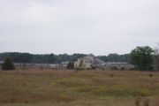
This is the back side of the main building
in this factory complex. There are a number of such factory complexes
on the site. I was being dogged by security guards as I drove around,
which means that I sometimes had to take the shot in front of me through
the fences rather than looking for better vantage points, or climbing up
on top of my car. While the large building is clearly visible, there
are many smaller buildings scattered behind the trees.
|
 |
This appears to be a maintenance building
and machine shop. It is actively in use supporting the cleanup. Despite
having passed through the main gate, we still have fences to contend with.
Each area within the Savanna site is secured with a separate ring of
chain link fence, creating a very compartmentalized environment.
|
 |
This building is interesting in that it
appears to have bits and pieces from several different generations. Also
notice the warning siren on the roof. That could be for weather warnings,
but is also likely used for warning of chemical and nuclear accidents.
Based on the layout of the building, I would guess that this was a fire
station. The larger building would be the garage for the fire trucks,
while the newer single story building would be the bunk house and living
quarters for the fire crews.
|
 |
Another older metal building, this time,
with doors that allow trains to pass through the building. While this
could be some kind of industrial storage, it is just as likely that this
is the building where they housed and did light maintenance on the rail
locomotives that were assigned to the base.
|
 |
Another photo of the underground bunkers.
This particular area had over 100 of these bunkers visible. The satellite
photo shows that there may have been over a 1000 in another part of the
facility. The Savanna site was the largest Army depot during its
peak operational years during WWII and the cold war.
|
| Recent News |
The Savanna site was all but finished as a
depot following Vietnam as depot facilities were moved towards the coasts.
The heavy manufacturing was ended by the end of WWII. Chemical weapons
went out of style in the 60’s, and the Army backed off of using nuclear
weapons after the cold war. That left the depleted uranium shell program
as the last major tenant besides the US Army Information Command, which
hosted a major data center and communications node.
All kinds of proposals have come and gone. Trucking companies would like
to use the warehouses, but Savanna is no where near any place important.
Various things such as a retirement home, rail car repair facility, dot
com server farm, telemarketing center, and fish farm has been proposed.
Barring that, much of the land has been turned over to the US Fish And
Wildlife, who has renamed the place the Lost Mound NWA. As part of being
a wildlife area, the facility is again mostly off-limits to all but
certain wildlife researchers.
The most recent proposal has come from the Sac and Fox Nation of
Oklahoma. They used to live in this area prior to losing the Black
Hawk war and being forced into exile. They have been attempting to
buy the Savanna site and turn it into a reservation for tribe members
who want to move back to Illinois. As part of their proposal, they
want to build a casino and bingo hall, a call center, a fuel blending
facility, a biodiesel plant, and an ethanol plant.
The latest report from the Savanna site Local Redevelopment Authority
says that it might take until 2014 to clean up the site to the point
where it is safe for the general public.
|
|
|
