Current Weather Conditions
John A. Weeks III
Saturday, April 20, 2024, 2:50:43 AM CDT
Home Photo Tours Rail Fan 12 Easy Steps
Aviation Spacecraft Highways & Bridges About The Author
 
Google Search
Maps   Groups   Images   Search
 
  Home
  • 12 Easy Steps
  • Aviation
  • Spacecraft
  • Highways & Bridges
    » Bridge Photography
      - MSP River Bridges
      - C & D Canal
      - Illinois River
      - Minnehaha Creek
      - Minnesota River
      - Mississippi River
        › Lake Itasca Area
        › Bemidji Area
        › Cass Lake - Ball Club
        › Grand Rapids Area
        › Blackberry - Crosby
        › Brainerd Lakes Area
        › Little Falls Area
        › St. Cloud Area
        › North Metro Area
        › Port Of Minneapolis
        › St. Anthony Falls Area
        › Mississippi Rvr Gorge
        › St. Paul Area
        › S St. Paul - Hastings
        › Red Wing - Winona
        › La Crosse Area
        › Lansing - Clinton
        › Quad Cities Area
        › Muscatine - Louisiana
        › St. Louis Area
        › Chester - Cairo
        › Miss - Tenn - Ark
          · New Madrid Flwy
          · Caruthersville Bridge
          · AW Willis Jr Bridge
          · Hernando De Soto
          · Memphis Suspn Rwy
          · Harahan Bridge
          · Frisco Bridge
          · Memphis-Arkansas Br
        › Ark - Miss - Louisiana
        › Louisiana Structures
      - Missouri River
      - St. Croix River
      - St. Louis River
      - Wisconsin River
      - Best Miss River Photos
      - Cable Stayed Bridges
      - McGilvray Road Bridges
      - I-35W Bridge Disaster
      - Miscellaneous Bridges
      - Madison County Bridges
      - Hist Br Weekend 2013
    » Road Geek Topics
  • Photo Tours
  • Rail Fan
  • About The Author
 
Site Search By JRank
Highways, Byways, And Bridge Photography
Memphis-Arkansas Memorial Bridge
I-55 Mississippi River Crossing At Memphis
Memphis, Tennessee

Memphis-Arkansas Memorial Bridge

• Structure ID: NBI: 79I00550101.
• Location: River Mile 734.7.
• River Elevation: 187 Feet.
• Highway: I-55.
• Daily Traffic Count: 40,000 (2003).
• Bridge Type: Continuous Steel Truss Through Deck.
• Length: 5,222 Feet Overall, 770 Foot Longest Span.
• Width: 52 Feet, 4 Lanes, 2 Sidewalks.
• Navigation Channel Width: 770 Foot Clear Channel.
• Height Above Water: 112 Feet.
• Date Built: Opened December 1949.
The Memphis-Arkansas Memorial Bridge was built in 1949 as part of US-40. It replaced the narrow traffic lanes that were attached to each side of the Harahan Bridge. The bridge later became part of the Interstate Highway system when I-55 was extended into Memphis.

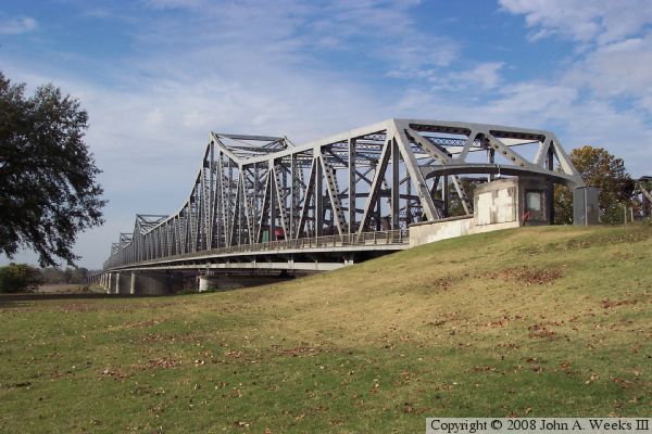
There are three bridges over the Mississippi River at this location. The three structures are approximately 150 feet apart. The upstream structure is the Harahan Bridge, a railroad bridge that once supported auto traffic. The Frisco Bridge is the middle structure. As a result of these two bridges being so close, the US Army Corps of Engineers required that their piers line up across the river channel to make navigation safer. The Memphis-Arkansas Memorial Bridge followed this same pier spacing when it was constructed.

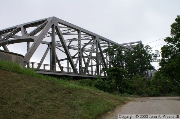
The third photo on this page resulted in a particularly painful event. I was somewhat frustrated in not being able to find a place where I could photograph the side of this bridge. I did find a limited view in front of the Metal Museum located just south of the bridge. In front of this museum was a large earthen work about 40 feet high. It was a gun emplacement from the Civil War. I decided that I could probably get a better picture if I was up there rather than down here. The only problem is that it was fairly steep. Well, I went ahead and climbed it anyway, and did get a nice photo. On the way down, I realized how steep and dangerous this was. To make matters worse, I was wearing a pair of well worn sneakers that offered almost no grip. I figured that if I fell, I'd just fall backwards and sit down, but then again, I'd try hard not to fall. About one third of the way down, I stepped on a twig, which rolled, and my theory about falling backwards and sitting down turned out not to work. I went toes over ears at least three times, falling 20 feet before I came to rest on a ledge. My camera went flying, and was now in at least three pieces. Worse, when I landed, my hand landed on a branch of a rose bush. One of the thorns went into the palm of my hand. After I realized that I was otherwise unhurt, except for wrenching my back, the rose thorn, and my demolished camera, my first thought was not about my safety. Rather, it was my pride. Did anyone see me do such a dumb thing like that? I slowly climbed the rest of the way down, collected my camera parts, and staggered to my beloved Ford Ranger. Safe at last, complete with air conditioning. The camera was fixable, and I used a lot of Advil for my back for a few days, but that rose thorn hurt like the devil for about two weeks. Still, I was lucky to get away so easy this time.

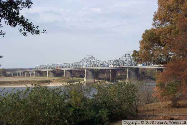
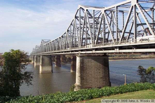
The photo above is the south face of the bridge looking towards Arkansas to the west as seen from EH Crump Park near the south corner of the structure. While the bridge does have sidewalks on each side of the highway, those sidewalks are no longer open for use by the public. As a result, there is no way for pedestrians or bicycles to cross the Mississippi River at Memphis. There is a proposal to add a trail crossing to the Harahan Bridge by installing a new deck on one of the inactive traffic lanes.


Memphis-Arkansas Memorial Bridge
The photo above is a view looking northwest from an earthwork located in De Soto Park built to support a Civil War gun emplacement. The photo below is a view from a vehicle crossing the bridge heading westbound towards Arkansas.

Memphis-Arkansas Memorial Bridge
These two photos are the Arkansas side of the river crossing. The photo above is the abutment on the northwest end of the structure. The photo below is looking along the south face of the bridge towards the main truss spans.

Memphis-Arkansas Memorial Bridge
These two photos are views from the Memphis end of the bridge. The photo above is looking down the south side of the bridge towards Arkansas. The photo above is the north side of the abutment on the Tennessee side of the river.

Memphis-Arkansas Memorial Bridge

Made With Macintosh
Authored by John A. Weeks III, Copyright © 1996—2016, all rights reserved.
For further information, contact: john@johnweeks.com