Current Weather Conditions
John A. Weeks III
Thursday, April 18, 2024, 1:08:15 PM CDT
Home Photo Tours Rail Fan 12 Easy Steps
Aviation Spacecraft Highways & Bridges About The Author
 
Google Search
Maps   Groups   Images   Search
 
  Home
  • 12 Easy Steps
  • Aviation
  • Spacecraft
  • Highways & Bridges
    » Bridge Photography
      - MSP River Bridges
      - C & D Canal
      - Illinois River
      - Minnehaha Creek
      - Minnesota River
      - Mississippi River
      - Missouri River
        › Fort Peck Area
        › Eastern Montana
        › Western North Dakota
        › Central North Dakota
        › South Dakota Interior
          · Mobridge Bridge
          · US-12 Bridge
          · Forest City Bridge
          · Oahe Dam
          · Powerhouse Road Br
          · Pierre Railroad Bridge
          · Fort Pierre Bridge
          · Big Bend Dam
          · Chamberlain-Oacoma
          · Lewis & Clark Mem
          · Chamberlain Railroad
          · Platte-Winner Bridge
        › Nebraska - S Dakota
        › Nebraska - Iowa (N)
        › Omaha Area
        › Nebraska - Iowa (S)
        › Nebraska - Missouri
        › Kansas - Missouri
        › Kansas City Area
        › West Central Missouri
        › East Central Missouri
        › St. Louis Area
      - St. Croix River
      - St. Louis River
      - Wisconsin River
      - Best Miss River Photos
      - Cable Stayed Bridges
      - McGilvray Road Bridges
      - I-35W Bridge Disaster
      - Miscellaneous Bridges
      - Madison County Bridges
      - Hist Br Weekend 2013
    » Road Geek Topics
  • Photo Tours
  • Rail Fan
  • About The Author
 
Site Search By JRank
Highways, Byways, And Bridge Photography
Powerhouse Road Bridge
SD-514 Missouri River Highway Crossing
Pierre, SD

Powerhouse Road Bridge

• Structure ID: NBI CEPMROSD0000009
• Location: River Mile 1071.1
• River Elevation: 1,420 Feet
• Highway: SD-514, Power House Road
• Daily Traffic Count: 300 (2005)
• Bridge Type: Steel Girder, Concrete Deck
• Length: 607 Feet, 152 Foot Longest Span
• Width: 26 Feet, 2 Lanes
• Navigation Channel Width: Non-Navigable
• Height Above Water: 14 Feet
• Date Built: 1957
This bridge was built as part of the Oahe Dam project. It provides easy access to the dam power house from Fort Pierre without traffic having to go up and over the dam. This is convenient for both the work crew and folks using the recreation areas below the dam. The bridge is located about 2/3 of a mile down stream of the overflow outlets on the west end of the dam. The river channel carries the overflow water to the main channel of the Missouri River.

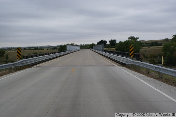
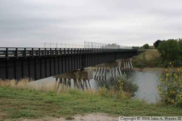
The Powerplant Road Bridge is a relatively simple structure. It was built by driving tubular piles into the riverbed. Some piles are vertical to better carry the load of the bridge, while some are set at an angle to help keep the bridge from moving sideways. There are 14 piles for each pier. A concrete cap was placed on top of the piles. The bridge steel was then erected across the piles. Finally, the road deck was built on top of the steel girders.


Powerhouse Road Bridge

Made With Macintosh
Authored by John A. Weeks III, Copyright © 1996—2016, all rights reserved.
For further information, contact: john@johnweeks.com