Current Weather Conditions
John A. Weeks III
Saturday, April 20, 2024, 4:13:27 AM CDT
Home Photo Tours Rail Fan 12 Easy Steps
Aviation Spacecraft Highways & Bridges About The Author
 
Google Search
Maps   Groups   Images   Search
 
  Home
  • 12 Easy Steps
  • Aviation
  • Spacecraft
  • Highways & Bridges
    » Bridge Photography
      - MSP River Bridges
      - C & D Canal
      - Illinois River
      - Minnehaha Creek
      - Minnesota River
      - Mississippi River
        › Lake Itasca Area
        › Bemidji Area
        › Cass Lake - Ball Club
        › Grand Rapids Area
        › Blackberry - Crosby
        › Brainerd Lakes Area
        › Little Falls Area
        › St. Cloud Area
        › North Metro Area
        › Port Of Minneapolis
        › St. Anthony Falls Area
        › Mississippi Rvr Gorge
        › St. Paul Area
        › S St. Paul - Hastings
        › Red Wing - Winona
          · Lock & Dam #3
          · Eisenhower Bridge
          · Lloyd Spriggle Mem
          · Lake Pepin Winter Rd
          · Milw Road Pontoon Br
          · Wabasha-Nelson Br
          · Pontoon Slough Br
          · Beef Slough Bridge
          · Buffalo Slough Br
          · Shively Slough Br
          · Lock & Dam #4
          · Lock & Dam #5
          · Lock & Dam #5A
          · Winona Main Channel
          · Winona N Channel Br
          · C&NW Winona Br
          · John A. Latsch Br
          · Winona Bridge Rwy
          · Lock & Dam #6
        › La Crosse Area
        › Lansing - Clinton
        › Quad Cities Area
        › Muscatine - Louisiana
        › St. Louis Area
        › Chester - Cairo
        › Miss - Tenn - Ark
        › Ark - Miss - Louisiana
        › Louisiana Structures
      - Missouri River
      - St. Croix River
      - St. Louis River
      - Wisconsin River
      - Best Miss River Photos
      - Cable Stayed Bridges
      - McGilvray Road Bridges
      - I-35W Bridge Disaster
      - Miscellaneous Bridges
      - Madison County Bridges
      - Hist Br Weekend 2013
    » Road Geek Topics
  • Photo Tours
  • Rail Fan
  • About The Author
 
Site Search By JRank
Highways, Byways, And Bridge Photography
Lock & Dam #3
Mississippi River Lock & Dam
Welch, Minnesota

Lock & Dam #3

• Structure: Lock & Dam #3.
• Location: River Mile 796.9
• Dam Width: 3,950 Feet Overall, 365 Foot Wide Dam Structure.
• River Elevation (Pool): 675 Feet.
• River Elevation (Outflow): 667 Feet.
• Water Fall: 8 Feet.
• Annual Lock Traffic: 12,791 Vessels, 7,301,000 Tons (2005).
• Date Opened: July 1938.
Lock & Dam #3 is located between Red Wing and Hastings, Minnesota, and is just south of Prairie Island. It is located in a marshy area of the river that features a number of channels, sandbars, and islands. The structure is somewhat unique in that the dam itself is not very long, while the river itself is rather wide. The bulk of the structure consists of earth embankments and dikes. The main dam structure consists of 4 roller gates. The lock structure is the standard size for the upper Mississippi of 110 feet wide by 600 feet long. While the structure went into operation in the summer of 1938, it underwent a major renovation from 1988 to 1991.

The structure is located just south of the Prairie Island Indian Reservation, home of the Treasure Island Resort & Casino. The Prairie Island Nuclear Power Station is just north of the dam, and just south of the casino. The power plant has been a sore spot with the Indian community for many years. Despite a good operating record, the Indians would like the power plant removed. The power plant supplies nearly half of the electricity to the twin cities area, so a shutdown is not in the cards. As a result, the Indians declared the reservation to be a non-nuclear area. This prevented the power company from using the access road through the reservation. As a result, Northern States Power was forced to build a new access road that skirted the boundary of the reservation.

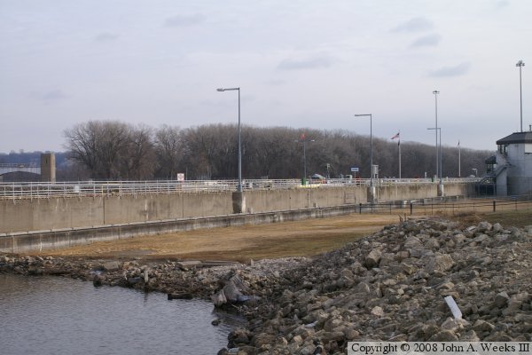
There is a curve in the river just upstream of the lock & dam. This has the effect of causing a cross-current near the entrance to the lock that makes river navigation dangerous. This has resulted in over 100 barge accidents. In 1993, a barge loaded with soybeans missed the lock entrance and crashed into the dam. The barge sank, blocking the river. In 2005, two barges broke free from a tow and went through one of the dam gates.

The US Army Corps of Engineers fears that a future accident could result in several barges breaking free and sinking in front of the dam, causing the river to rise. Higher water levels could cause the cross-current to erode the dike on the Wisconsin side of the river causing the dam to fail and the river channel changing course. Not only would this prevent river navigation north of Red Wing, but the change in the river channel would force a shutdown of the nuclear powerplant due to reduced water levels leaving their cooling water intakes high and dry. The US Army Corps of Engineers have rated this structure as the second most likely Corps structure to fail. To address the issues, the Corps has requested $70-million in economic stimulus funds to modify the lock & dam and reinforce the riverbanks.

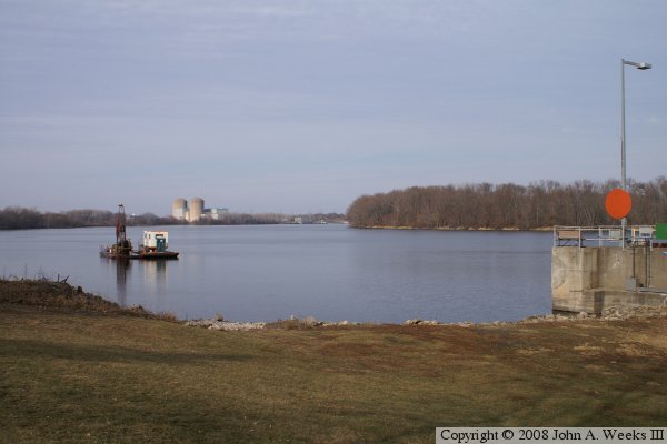
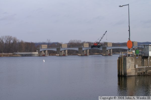
The fifth photo below shows the power station in the distance just upstream from the lock & dam. Also visible in that photos is the curve in the river leading up to lock entrance.


Lock & Dam #3
Lock & Dam #3
Lock & Dam #3
Lock & Dam #3
Lock & Dam #3
Lock & Dam #3

Made With Macintosh
Authored by John A. Weeks III, Copyright © 1996—2016, all rights reserved.
For further information, contact: john@johnweeks.com