| Highways, Byways, And Bridge Photography |
The I-35W Bridge On Memorial Day
A Look At The I-35W Saint Anthony
Falls Bridge Lit Up In Red, White,
And Blue For Memorial Day 2012
The new I-35W Saint Anthony Falls Bridge features an innovative LED lighting
system where each LED element is individually addressable, allowing any
color in the spectrum to be displayed. On most nights, the bridge is bathed
in a eerie blue glow that looks like something out of a science fiction movie.
However, the bridge is occassionaly lit up in other colors for special
occasions.
One such special occasion was the weekend of May 25-28, 2012, to
celebrate Memorial Day. The lighting scheme as a linear series of vertical
red, white, and blue stripes, identical to the Veterans Tribute in November
of 2011. However, while the Veterans Tribute featured the strips in motion
crawling south across the river, for Memorial Day, the stripes on the east
side of the bridge were not moving, but the stripes on the west side of the
bridge were moving. The moving stripes require short exposure times that
are only possible using very high camera ISO settings. However, with the
stripes not moving on the east side of the bridge, it was possible to take
some longer exposure photos with lower ISO settings to get better images.
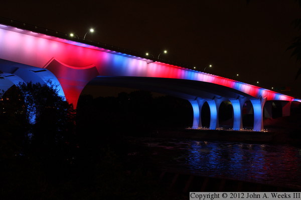
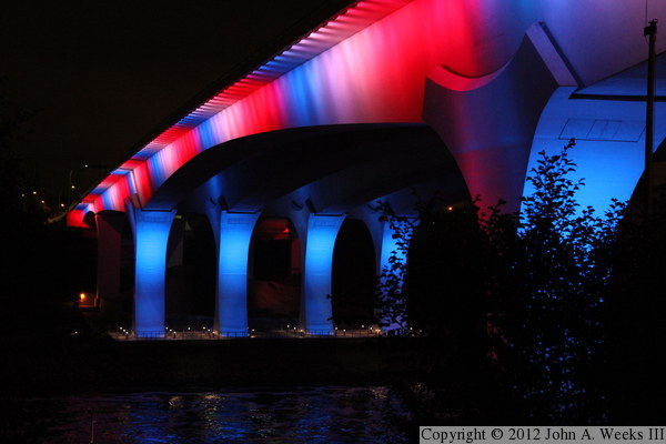
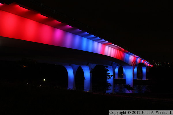
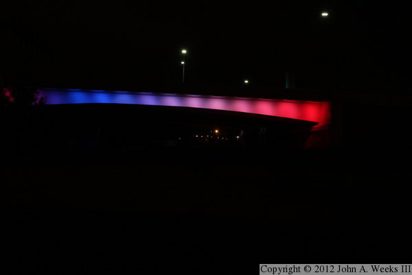
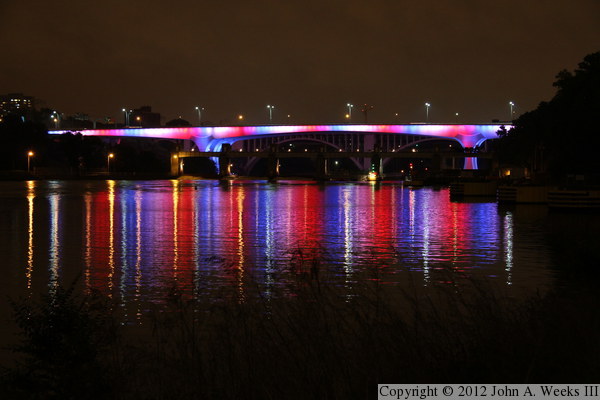
The photo above is the downstream east face of the Saint Anthony Falls Bridge
as seen from the south riverbank. The vantage point is standing near the
south main bridge pier of the nearby 10th Avenue Bridge, located just
downstream of the I-35W bridge.
Note—these materials are covered by copyright and may not be
used without written permission.
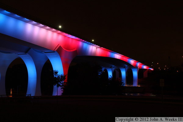
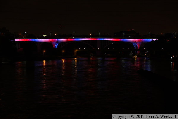
This photo is another view of the downstream east face of the I-35W bridge
as seen from the bicycle trail that runs between the river and the West
River Parkway. We are again looking north across the Mississippi River
in this photo.
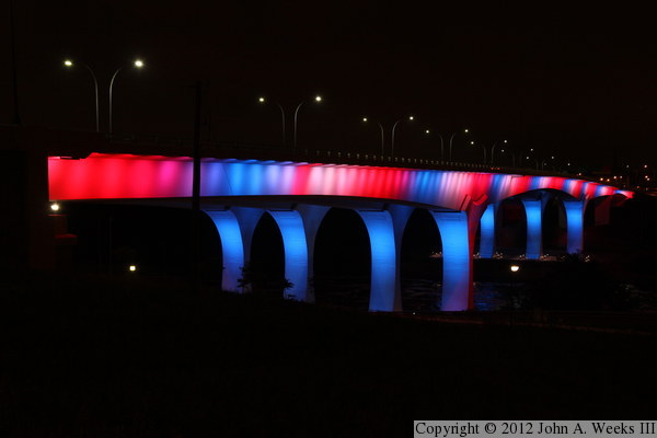
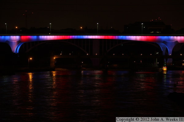
This photo is looking north across the Mississippi River along the downstream
east face of the I-35W Saint Anthony Falls Bridge. The LED light panels
are located under the edge of the bridge deck. They point towards the
bridge, illuminating the underside of the deck and the side of the
concrete spans.
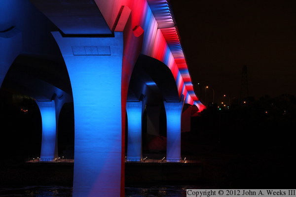
This photo is looking north across the Mississippi River along the upstream
west face of the I-35W bridge. The vantage point is a small clearing above
the Lower Saint Anthony Falls Lock & Dam that can be accessed from the
bicycle trail running along the West River Parkway. The colors were moving
on this side of the bridge. Note that it is blue directly above the main
bridge pier at the right edge of the photo.
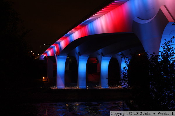
This photo was taken from the same location as the photo directly above,
showing the upstream west face of the I-35W bridge. In this view, the pier
on the right side of the photo is partly red, and partly blue, demonstrating
that the light effect is indeed moving.
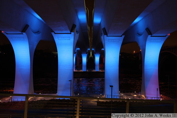
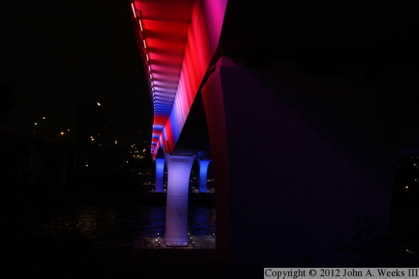
This view is looking north across the Mississippi River from directly under
the gap between the two parallel bridge spans. The vantage point is the
walkway leading down to the observation deck at the base of the piers.
From this location, the bridge looks like it is lit up in its normal blue.
The only hints of the light show are the tinges of purple along the bottom
of the outside piers, and the small right spot at the top of the outside
piers.
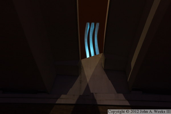
This photo is looking south towards the south bridge abutment. The curved
blue lines are the bridge monument, which is modeled after the international
symbol for running water. The monument is above the traffic deck, so we are
looking up at a 45-degree angle. Light from the street lamps above the
traffic lanes creates the inverted V pattern.
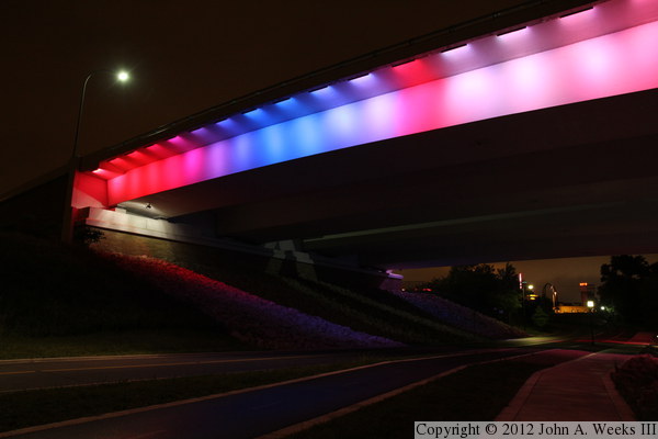
This photo is the downstream side of the south bridge abutment as seen from
the sidewalk along the West River Parkway. Downtown Minneapolis is located
just west of the location. The building visible in the distance under the
bridge is the Guthrie Theater.
This photo is the downstream east side of the I-35W Saint Anthony Falls
Bridge. The vantage point is about halfway up the river bluff on the
south side of the Mississippi River. The camera is located just below the
level of the bridge structure, putting us about 75 feet above the water level
This is my favorite view of the I-35W bridge as seen from the top of the
river bluff on the south side of the river. I was actually standing just
under the upstream edge of the 10th Avenue Bridge, which crosses the
Mississippi River parallel to and just downstream from the I-35W bridge.
The camera is located about 120 feet above the water level at this
location. This allows us to see the street lights above the bridge,
and just barely make out the guard rail along the edge of the bridge deck.
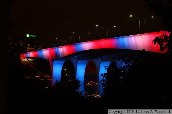
This photo is looking south across the Mississippi River. The vantage point
is standing next to the north main bridge pier of the nearby 10th Avenue
Bridge. This is a great location in the winter when the trees are bare,
but a good chunk of the bridge is obscured in the summer by the leaves.
The main river span is on the right half of the photo. The green sign
in the background is the Holiday Inn Metrodome.
This photo is looking south across the Mississippi River along the downstream
east face of the structure. The bridge has a slight curve on the north end
as it flares out for the exit ramps to University Avenue and 4th Street. The
LED light panels run down the outside edge of the bridge, and are pointed
towards the bridge structure.
This photo is the secondary span at the north end of the I-35W bridge. This
span crosses over an old railroad yard. There is still one track that runs
along the edge of the river bluff, but it is rarely used. There is also
a service road for the University of Minnesota passing under the structure.
The north bridge abutment is on the right side of the photo.
This view is looking west towards the south main bridge piers of the I-35W
Saint Anthony Falls Bridge. The vantage point is the deck of Northern Pacific
Bridge #9, and old railroad bridge that has been converted into a bicycle
path. The lock and dam is located next to the bridge piers, but it was
too late at night for it to be lit up.
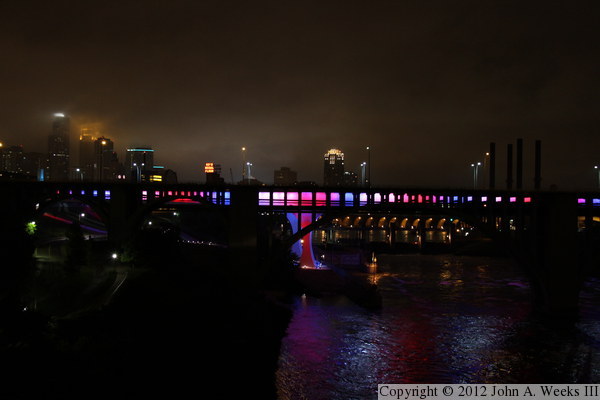
This is another view looking upstream from Northern Pacific Bridge #9,
with downtown Minneapolis located in the background. This night, May 26,
2012, was stormy, overcast, and raining on and off. The cloud base was
about 500 feet above the ground, which added a spooky glow to the
downtown area and partially obscured the tops of the buildings. The
black object in front of the I-35W bridge is the 10th Avenue Bridge,
a large concrete arch bridge dating from the 1920s.
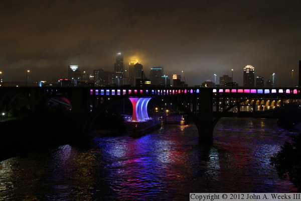
This is a closer view of the main bridge piers and downtown Minneapolis
as seen from the north end of Northern Pacific Bridge #9. The two parallel
yellow lines above the bridge piers is the Guthrie Theater. The yellow
lighted sign to the right of the bridge piers is the Gold Medal Flour
sign. The sign was abandoned in 1965 when the mill closed down, but it
was refurbished and lit up in 1998 as part of the construction of the
Mill City Museum. The two horizontal green lines are the 5th Street
Towers, two tall buildings on the north edge of downtown.
This photo is looking downstream towards the west face of the I-35W bridge.
Our vantage point is the parking area at the Mill Ruins Park. The Lower
Saint Anthony Falls Lock & Dam is located just in front of the bridge.
This photo is over-exposed just a bit to bring out the reflections on
the surface of the Mississippi River.
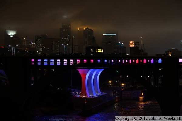
These last two photos are looking downstream towards the I-35W Saint Anthony
Falls Bridge from the deck of the Stone Arch Bridge. Due to the orientation
of being 50 feet above the water, and the dam (with its 25 foot drop), the
geometry doesn't work out to produce the same type of reflections on the
surface of the river. The photo above is the full length of the bridge
that is visible from the Stone Arch Bridge, while the photo below is a
closer view focused on the main river span. This side of the bridge has
the moving stripes. Compare the colors above the right pier, which is
red in the upper photo, but blue in the lower photo.
|
