
|
John A. Weeks III
Thursday, July 16, 2026, 5:09:03 PM CDT |
|||
| Home | Photo Tours | Rail Fan | 12 Easy Steps |
| Aviation | Spacecraft | Highways & Bridges | About The Author |
|
|
|
|||||||||||||||||
I-35W Bridge CollapseBridge Collapse Investigation Focus Area — October, 2007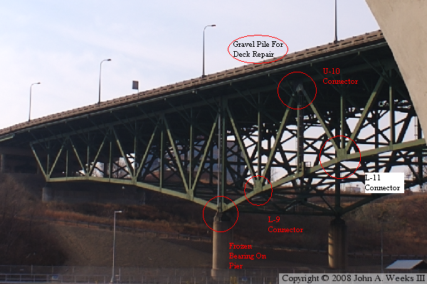
The photo above is the I-35W bridge taken in November of 2006, about 8 months
before the collapse. The photo below was taken about 3 weeks after the
disaster. These photos represent pre-collapse and post-collapse views of
the area where the NTSB is focusing their investigation efforts. The
NTSB typically takes 12 to 18 months to compete this type of investigation,
so the information here is preliminary and perhaps speculative in nature.
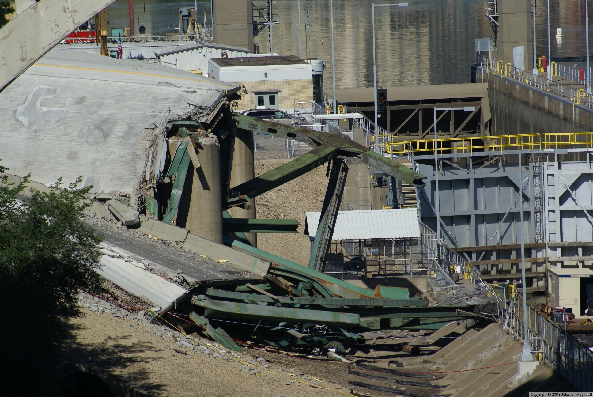
The situation before the crash is that the south end bearings were frozen. Post collapse views show that the bearing have not been moving. These bearing are in place to allow the entire bridge to move as it expands and contracts during heating and cooling cycles. With the bearing inoperative, the bridge would have to flex and bend. To aggravate the situation, the Twin Cities area had been experiencing a spell of unusually hot weather, with the temperature being 91 degrees at the time of the collapse. A second unusual factor is that the bridge was undergoing repair work on the deck. The normal 8 lanes were reduced to 2 lanes each direction, with two lanes each direction being closed for repair work. The northbound lanes had a large pile of gravel placed right above the U-9 and U-10 connector joints. While the bridge should have been able to handle this weight with no problem, it did alter the normal distribution of weight on the structure and add a constant additional load to the already heat stressed connector joints. The third leg of the disaster concerns the gusset plates that held the beams together at the connector joints. These plates vary from one-half inch to one inch in thickness. There is speculation that the one-half inch plates may have been too thin to support the weight of the bridge, a design flaw that may have been an accident waiting to happen. In addition, recent inspections have found that rust was attacking these gusset plates. The L-11 gusset plate had lost one-half of its thickness in places due to rust. To aggravate this situation, anti-ice solution and salt may have collected in this area speeding up the corrosion, and bird droppings may have accumulated in this area making inspections all the more difficult. The Minneapolis Star Tribune reports that connectors L-9, U-10, and L-11 all show evidence of pre-collapse damage. The failure of any one of these gusset plates would start a chain reaction of failures that would lead to the collapse of the bridge. The collapse aftermath shows that something unusual did happen in this area of the bridge. While the rest of the bridge fell straight down, the area near the southern piers is shifted to the east. The photo below shows the southbound lanes sitting on the pier that normally would support the northbound lanes, and the northbound lanes fell to the east of bridge the alignment. This seems to suggest that the east side of the structure failed, it then sagged, and the now wounded structure collapsed by falling and pivoting to the east. The now disconnected truss fell back slightly and landed in the water. The north end of the truss lost its balance and fell backwards. The remaining spans then lost their lengthwise support and fell off of their piers. I am sure that the NTSB will put all these pieces together and tell the complete story of the death of this bridge. What most of us Twin Cities residents, some who were on the bridge, and others who crossed this bridge dozens of times in the days before the collapse, are wondering about is what was special about 6:05PM on August 1, 2007? Why not 6:02PM, or 6:07PM, or July 29? Update January 15, 2008 — the NTSB issued their first formal update on the I-35W disaster investigation. They announced that there was a design flaw in the structure. The gusset plates at the U-10 and L-11 connections were 50% too thin to meet the design requirements. It appears that it was a mathematical error made by a draftsman, and that error was not caught when it was reviewed by the project engineer. The bridge contained eight of these connector joints, for a total of 16 gusset plates. In the bridge collapse, all 16 of the undersized gusset plates showed signs of pre-collapse damage. This means that at least one gusset plate failed, leading to the failure of the rest of the similar gusset plates. When enough of these gusset plates failed, the bridge could no longer support itself, and it collapsed. The interesting part is that the NTSB still does not know why the first gusset plate failed. Despite being too thin, it did stand up for 40 years. The NTSB was not able to force the bridge to fall in its computer models without putting unrealistic forces on the bridge. To summarize, we now know the sequence of events that lead to the collapse, except that we do not know which gusset plate failed first, nor do we know what triggered that first gusset plate to fail. 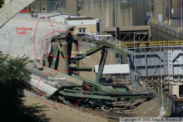
Click here for an enlargement of
the upper photo and
the lower photo. Note
that these are very large downloads. You may need to enlarge your
browser window or use the zoom feature.
What made this page possible is my discovery of the upper photo showing the east side of the south end of the bridge prior to the collapse. I did not know that I had this photo. It was taken by accident when I was actually shooting at something else. The I-35W bridge was only about one inch by one inch on a 4 by 6 print. Since it was taken with a digital SLR camera, the camera raw photo ended up being about 3 feet by 5 feet, so it was easy to pick out a 5 inch by 7 inch section of the raw image and still have the camera original level of detail.
|
|
|
Authored by John A. Weeks III, Copyright © 1996—2016, all rights reserved. For further information, contact: john@johnweeks.com
|