Current Weather Conditions
John A. Weeks III
Friday, March 29, 2024, 6:48:39 AM CDT
Home Photo Tours Rail Fan 12 Easy Steps
Aviation Spacecraft Highways & Bridges About The Author
 
Google Search
Maps   Groups   Images   Search
 
  Home
  • 12 Easy Steps
  • Aviation
  • Spacecraft
  • Highways & Bridges
    » Bridge Photography
      - MSP River Bridges
      - C & D Canal
      - Illinois River
      - Minnehaha Creek
      - Minnesota River
      - Mississippi River
        › Lake Itasca Area
        › Bemidji Area
        › Cass Lake - Ball Club
        › Grand Rapids Area
        › Blackberry - Crosby
        › Brainerd Lakes Area
        › Little Falls Area
        › St. Cloud Area
          · Champion Dam
          · City Bridge
          · Sartell Bridge
          · Bridge Of Hope
          · Sauk Rapids Bridge
          · Old Sauk Rapids Br
          · BNSF St. Cloud Br
          · Veterans Bridge
          · Granite City Crossing
          · Old DeSoto Bridge
          · University Bridge
          · St. Cloud Dam
          · Sportsman Island Br
          · Clearwater Bridge
        › North Metro Area
        › Port Of Minneapolis
        › St. Anthony Falls Area
        › Mississippi Rvr Gorge
        › St. Paul Area
        › S St. Paul - Hastings
        › Red Wing - Winona
        › La Crosse Area
        › Lansing - Clinton
        › Quad Cities Area
        › Muscatine - Louisiana
        › St. Louis Area
        › Chester - Cairo
        › Miss - Tenn - Ark
        › Ark - Miss - Louisiana
        › Louisiana Structures
      - Missouri River
      - St. Croix River
      - St. Louis River
      - Wisconsin River
      - Best Miss River Photos
      - Cable Stayed Bridges
      - McGilvray Road Bridges
      - I-35W Bridge Disaster
      - Miscellaneous Bridges
      - Madison County Bridges
      - Hist Br Weekend 2013
    » Road Geek Topics
  • Photo Tours
  • Rail Fan
  • About The Author
 
Site Search By JRank
Highways, Byways, And Bridge Photography
Sportsman Island Bridge
Mississippi River Bridge Ruins
Saint Cloud, MN

Sportsman Island Bridge

• Structure ID: N/A
• Location: River Mile 924.4
• River Elevation: 957 Feet
• County: Stearns
• Highway: Sportsman Island Road (Now Abandoned)
• Daily Traffic Count: 0, Bridge Is Closed
• Bridge Type: Through Truss
• Bridge Length: 110 Feet (Estimated)
• Bridge Width: 16 Feet (Estimated)
• Height Above Water: 16 Feet (Estimated)
• Date Built: ???
Zebulon Pike explored the upper Mississippi River in the early 1800s looking for the source of the Mississippi River. He took a wrong turn and never did make it to Lake Itasca. He did, however, make enough of an impact that Pike’s Peak was named in his honor. Pike described a section of the Mississippi River below the present day city of Saint Cloud that was a tangle of smaller channels. Many of these channels were blocked by beaver dams, so Pike named this area Beaver Islands.

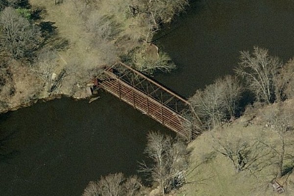
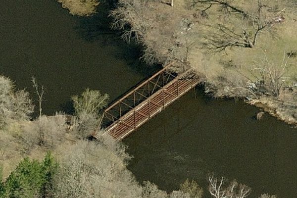
Early settlers attempted to farm some of these islands, however, the frequent floods made that impractical. George Friedrich, a biology professor from the nearby Saint Cloud State University, purchased many of the Beaver Islands in 1933 to preserve them. He later donated these islands to the college. At the time, many of the islands were connected with bridges. The largest island, Sportsman Island, was connected to the mainland by a steel truss bridge. A large flood in 1939 resulted in most of the bridges being destroyed by ice chunks.

The bridge to Sportsman Island survived the flood. At some point later, the roadway to the island was abandoned. The deck was removed from the bridge, but the metal structure was left in place. A golf course was established to the south of the old bridge and a subdivision was built to the north of the structure. The bridge was more or less forgotten except by the few families who could see the bridge remains from their homes.

The bridge was rediscovered in 2009 and received a bit of local publicity. Photographer Adam Studer visited the island and photographed the bridge. His photo was used in University materials promoting a Beaver Islands photography contest.

I have been unable to obtain permission to visit the Sportsman Island Bridge from the west bank of the Mississippi River. The local residents were a bit bothered by the publicity, and I respect their rights to their privacy. The country club also would not give me permission to cross their property. As a result, I plan to visit the bridge in 2010 using a canoe. There is a boat landing 1.6 miles north of the structure.

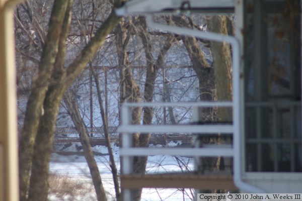
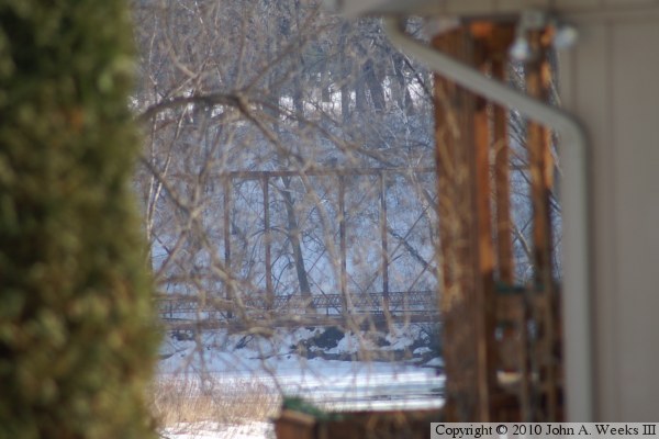
The photos above and below are views looking southeast from Island View Drive, which branches off of Sportsmans Island near the Mississippi River on the south end of Saint Cloud. These photos, shot between homes located along the river, are the only public glimpses available of the bridge from the mainland. The bridge is totally obscured by trees in the summer time, and is only visible from this location in winter.


Sportsman Island Bridge
These two photos were clipped from an Internet mapping service. The photo above is looking west while the photo below is looking north. The mainland is on the top left in the photo above, and on the bottom left in the photo below. Despite looking at every inch of the Mississippi River in aerial photographs, I did not see this bridge prior to learning about Studer’s photograph. It was obscured by trees and hidden in a shadow on recent aerial photos. Since that time, these birds eye views have been made available on MSN Maps.

Sportsman Island Bridge

Made With Macintosh
Authored by John A. Weeks III, Copyright © 1996—2016, all rights reserved.
For further information, contact: john@johnweeks.com