Current Weather Conditions
John A. Weeks III
Saturday, May 18, 2024, 10:02:06 PM CDT
Home Photo Tours Rail Fan 12 Easy Steps
Aviation Spacecraft Highways & Bridges About The Author
 
Google Search
Maps   Groups   Images   Search
 
  Home
  • 12 Easy Steps
  • Aviation
  • Spacecraft
  • Highways & Bridges
    » Bridge Photography
      - MSP River Bridges
      - C & D Canal
      - Illinois River
      - Minnehaha Creek
      - Minnesota River
      - Mississippi River
      - Missouri River
      - St. Croix River
        › Upper St. Croix River
        › Lower St. Croix River
          · Nevers Dam
          · St. Croix Falls Dam
          · US-8 Bridge
          · Highway 243 Bridge
          · Cedar Bend RR Br
          · Arcola High Bridge
          · WI Central RR Ruin
          · St. Croix Boom Site
          · Stillwater Lift Bridge
          · New St Croix R Br
          · C&NW RR Bridge
          · Walnut Street Cswy
          · Toll Bridge (Old)
          · I-94 Interstate Br
          · Point Douglas Draw
          · BNSF RR Bridge
      - St. Louis River
      - Wisconsin River
      - Best Miss River Photos
      - Cable Stayed Bridges
      - McGilvray Road Bridges
      - I-35W Bridge Disaster
      - Miscellaneous Bridges
      - Madison County Bridges
      - Hist Br Weekend 2013
    » Road Geek Topics
  • Photo Tours
  • Rail Fan
  • About The Author
 
Site Search By JRank
Highways, Byways, And Bridge Photography
Nevers Dam
Former Saint Croix River Dam
Saint Croix Falls, WI

Nevers Dam

• Location: River Mile 63.8.
• Structure Type: Wood, Stone, Concrete.
• Structure Width: 624 Foot Main Structure, 1,900 Feet Overall.
• River Elevation (Pool): 755 Feet, 772 Feet Historically.
• River Elevation (Outflow): 755 Feet.
• Water Fall: 0 Feet, 17 Feet Historically.
• Date Built: Built 1889, Removed 1955.
The main use for the Saint Croix River in the late 1800s and very early 1900s was to float logs from the woods in northern Wisconsin down to the mills on the Saint Croix and Mississippi Rivers. The Saint Croix was in an ideal location, but it was not the ideal river. It was often broad and shallow, whereas lumberman preferred a deeper faster river. One key issue was Angle Rock. Massive log jams would build up at Angle Rock. This would cut off the supply of logs and cause the mills to shut down until the jams could be cleared.

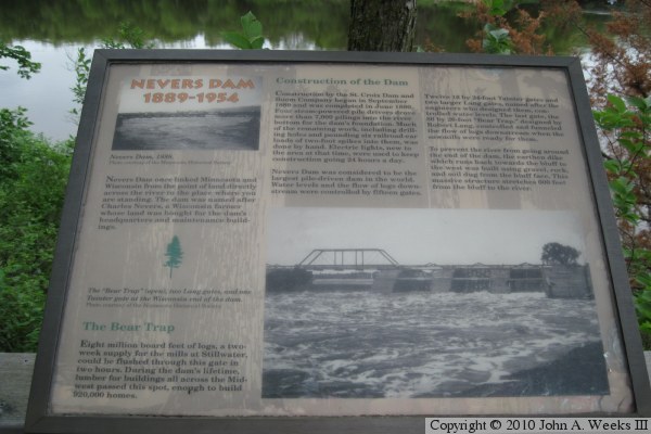
To address the problem of the log jams, Frederick Weyerhaeuser decided to build a dam about 11 miles up river from the Saint Croix Falls. They leased land from local farmer Charlie Nevers. They sunk piles into the river, built stone cribs, and installed 15 sluicing gates and one huge eighty foot wide Bear Trap Gate. The dam was very expensive, costing $250,000 in period money. The investors hoped to recover this cost by charging tolls on wood that passed through the dam, and by improved operations of the boom site and mill at Stillwater. At the time, this was the largest wooden dam in the world, and the Bear Trap Gate was the largest dam gate in the world.

The dam was operated on a two week schedule. Water would be backed up behind the dam for 2 weeks. Then lumberman would be told to get their logs into the river. Once the gates were opened, the logs would slide past the dam and ride the wave of high water downstream. As soon as the logs were through, the dam would be closed up for another two weeks.

The supply of logs was largely exhausted by 1902. The dam was sold to Northern States Power. NSP wanted to use the dam to control the river flow while it was building the new dam at Saint Croix Falls. NSP ran the project until the 1950s. In May of 1954, high water damaged the structure. The dam had lost much of its usefulness after the Saint Croix Falls Dam was completed. Now that Nevers Dam was unsafe, NSP decided to completely remove the remaining structure. There are no remains of the dam in the river proper. A 100 foot section of the dike remains in place on the Wisconsin side, and much of the dike remains intact on the Minnesota side of the river within the Saint Croix Wild River State Park.

The Nevers Dam also functioned as a highway crossing over the Saint Croix River. The top of the dam featured a flat platform suitable for buggy traffic and later for cars. The 85 foot long central gate featured a small through truss bridge to carry traffic over the discharge outlet. When the dam was removed, locals lost a convenient river crossing point.

The Nevers Dam featured a very small electrical generator. It was used to power electrical lights on the structure to allow log processing to work 24 hours a day. This was the first electrical equipment in the area, and people reportedly drove from miles around to see the lights in operation at night.

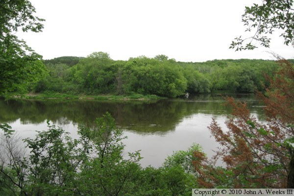
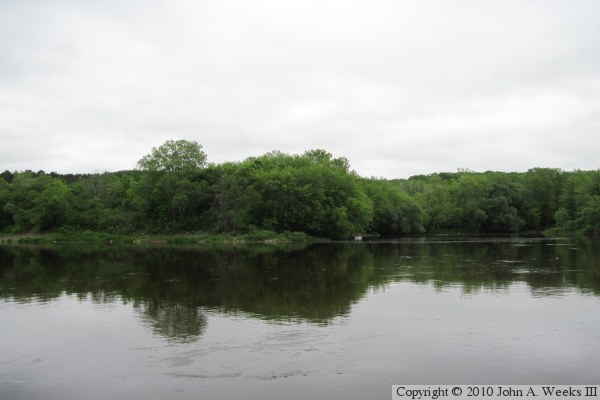
The photo above is the Minnesota side of the Saint Croix River at the former dam site as seen from the east bank of the river. There is no part of the dam remains visible from this vantage point, but part of the earthen dike still exists further inland on the Minnesota side of the river.


Nevers Dam
I visited the Wild Rivers State Park during their open house in June of 2010. This guide sign (above) points the way from the picnic area to the site of the dam remains. The short trek involves walking down a steep paved trail to get to the bottom of the river bluffs. The trail then follows the top of the dam embankment (below) for its 1,200 foot length.

Nevers Dam
Nevers Dam
The Nevers Overlook (above) is located at the end of the dam embankment near the west bank of the Saint Croix River. The photo below is the view looking east across the Saint Croix River to the Wisconsin side of the river.

Nevers Dam
Nevers Dam
These two guide signs tell the story of Nevers Dam. The sign above tells the story of the construction and operation of the dam, while the photo below tells the story of the end of the logging era, and the removal of the dam.

Nevers Dam
Nevers Dam
The photo above is a view looking up along the stairs on the downstream side of the dam embankment. The photo below is a view of the overlook as seen from the edge of the Saint Croix River. The embankment is about 25 feet tall.

Nevers Dam
Nevers Dam
The photo above is looking east across the river towards the Wisconsin side of the river from the west bank of the Saint Croix. A boat is visible on the far side of the river. It is located near a public water access point that was the vantage point for the photo at the top of the page. The photo below is a view looking west down the top of the dam embankment on the Minnesota side of the river.

Nevers Dam

Made With Macintosh
Authored by John A. Weeks III, Copyright © 1996—2016, all rights reserved.
For further information, contact: john@johnweeks.com