Current Weather Conditions
John A. Weeks III
Tuesday, March 19, 2024, 1:45:31 AM CDT
Home Photo Tours Rail Fan 12 Easy Steps
Aviation Spacecraft Highways & Bridges About The Author
 
Google Search
Maps   Groups   Images   Search
 
  Home
  • 12 Easy Steps
  • Aviation
  • Spacecraft
  • Highways & Bridges
    » Bridge Photography
      - MSP River Bridges
        › 10th Avenue Bridge
        › Arcola High Bridge
        › Betty Adkins Bridge
        › Bloomington Ferry
        › Bloomington Fry Tr
        › BNSF RR Bridge
        › Boom Island Foot Br
        › Broadway Avenue Br
        › C&NW Bridge (1)
        › C&NW Bridge (2)
        › Camden Bridge
        › Cedar Avenue Bridge
        › Cedar Ave Br (Old)
        › Cedar Ave Bicycle Br
        › Cedar Bend RR Br
        › Chaska Bridge (Old)
        › Chaska Swing Bridge
        › Chaska Trestle
        › Coon Rapids Dam
        › CP RR Bridge
        › Dan Patch Line Br
        › Dartmouth Bridge
        › East Channel Bridge
        › East Channel RR Br
        › East River Flats Br
        › Endless Bridge
        › F. W. Cappelen Mem
        › Father Henn Bluffs
        › Father Louis Henn Br
        › Ferry Street Bridge
        › First Avenue Bridge
        › Fort Road Bridge
        › Fort Snelling Br (Old)
        › Fort Snelling High Br
        › Great Western Bridge
        › Grey Cloud Channel
        › Grey Cloud Island Br
        › Grey Cloud Trail Br
        › Hastings High Bridge
        › Hastings Spiral Br
        › Holmes St Ped Bridge
        › Highway 243 Bridge
        › I-35W Bridge
        › I-35W Bridge (Old)
        › I-494 Bridge
        › I-694 Bridge
        › Interstate Bridge
        › Intercity Bridge
        › L St. Anthony F L&D
        › Lafayette Bridge
        › Lake Street Bridge
        › Lewis Street Bridge
        › Lexington Bridge
        › Lions Levee Pk Foot
        › Lock & Dam #1
        › Lock & Dam #2
        › Long Meadow Bridge
        › Lower Bridge
        › Lowry Bridge (Old)
        › Meeker Island L&D
        › Mendota Bridge
        › Merriam Street Br
        › Mill Ruins Park Br
        › Milwaukee Road Br
        › M&StL Bridge
        › Miss River Bridge 15
        › MN-101 Bridge
        › MN-41 Backchannel
        › MN-41 Back Ch (Old)
        › MN-41 Bridge
        › New Saint Croix Br
        › New Trunk-41 Bridge
        › Nicollet Island RR Br
        › North Miss Park Pier
        › NP Bridge #9
        › NP RR Bridge
        › Pike Island Bridge
        › Plymouth Bridge
        › Point Douglas DB
        › Raspberry Island Br
        › Richard P. Braun Br
        › Robert Street
        › Rock Island Swing Br
        › Runway 30 Light Br
        › Short Line Bridge
        › Smith Avenue High
        › Southeast Steam Plant
        › St. Anthony Falls Br
        › St. Anthony Falls Lab
        › St. Anthony Falls PP
        › St. Croix Boom Site
        › St. Croix Falls Dam
        › Stillwater Lift Br
        › Stone Arch Bridge
        › Third Avenue Bridge
        › Toll Bridge (Old)
        › U St. Anthony F L&D
        › US-8 Bridge
        › Wabasha Street Bridge
        › Wakota Bridge
        › Wakota Bridge (Old)
        › Walnut Street CW
        › Washington Ave Br
        › WI Central RR Br
        › WI Central RR Ruins
        › Wright Co Hwy 42
      - C & D Canal
      - Illinois River
      - Minnehaha Creek
      - Minnesota River
      - Mississippi River
      - Missouri River
      - St. Croix River
      - St. Louis River
      - Wisconsin River
      - Best Miss River Photos
      - Cable Stayed Bridges
      - McGilvray Road Bridges
      - I-35W Bridge Disaster
      - Miscellaneous Bridges
      - Madison County Bridges
      - Hist Br Weekend 2013
    » Road Geek Topics
  • Photo Tours
  • Rail Fan
  • About The Author
 
Site Search By JRank
Highways, Byways, And Bridge Photography
Stone Arch Bridge
Historic Great Northern Railroad Mississippi River Crossing
Minneapolis, MN

Stone Arch Bridge

• Structure ID: NBI: 27004.
• Location: River Mile 853.7.
• River Elevation: 751 Feet.
• Highway: Bicycle Trail & Pedestrian Crossing.
• Railroad: Former Great Northern Railroad.
• Bridge Type: Stone Arch, Deck Truss Section Over Lock.
• Length: 2,100 Feet Overall, 197 Foot Main Span.
• Width: 1 Lane, 25 Feet.
• Navigation Channel Width: 56 Feet.
• Height Above Water: 25 Feet.
• Date Built: Opened 1883.
The Stone Arch Bridge was built in the 1880s by famous railroad tycoon James J. Hill. At the time, engineers thought that it would be impossible to build a stone arch bridge for rail traffic. They believed that vibrations from passing trains would cause the stone to crumble. Now that 125 years have passed, not only has J.J. Hill been proven right, but the Stone Arch Bridge is now one of the oldest surviving bridges over the Mississippi River.

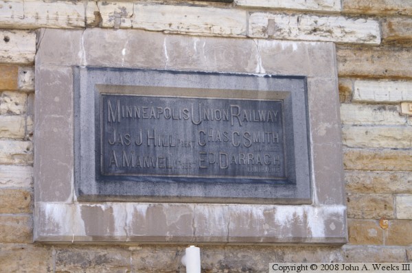
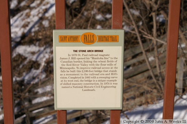
In the early 1880s, the main depot in Minneapolis was the Minneapolis Union Depot. Being a union depot, it served more than one rail line. Each railroad had to figure out how to bring their trains into the depot. Other railroad had routes into downtown Minneapolis, such as the Milwaukee Road Short Line and the rival Northern Pacific, which had a bridge over the Mississippi near the university campus.

Great Northern trains would come up from Chicago along the east side of the Mississippi over Chicago, Burlington, and Quincy tracks. The trains would pass Daytons Bluff in Saint Paul, then pass through the Como Yards and into the Midway area. All that was needed was to find a way to connect the Midway area with downtown Minneapolis. The shortest route was a bridge over the Mississippi River near the east bank mills, and curving along the west river bank, ending up right at the entrance to the Union Depot.

The Stone Arch Bridge served rail passengers through high times and panics, through the boom times in the 1920s and the depression of the 1930s, and through two world wars. The star of the passenger service was the Empire Builder, whose timetable was adjusted so passengers could enjoy the scenery of the mountains through space age looking vista dome cars. But the railroad could not keep up with the automobile, and the passenger rail business became unprofitable. Amtrak was formed to take over passenger rail service on May 1, 1971. Amtrak continued to operate the Empire Builder over the Stone Arch Bridge. But on March 1, 1978, Amtrak opened the new depot on Cleveland Avenue in the Midway area between Saint Paul and Minneapolis. The last train crossed the Stone Arch Bridge on that day.

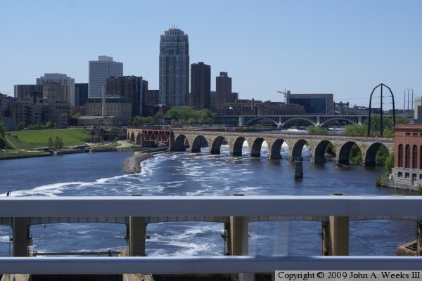
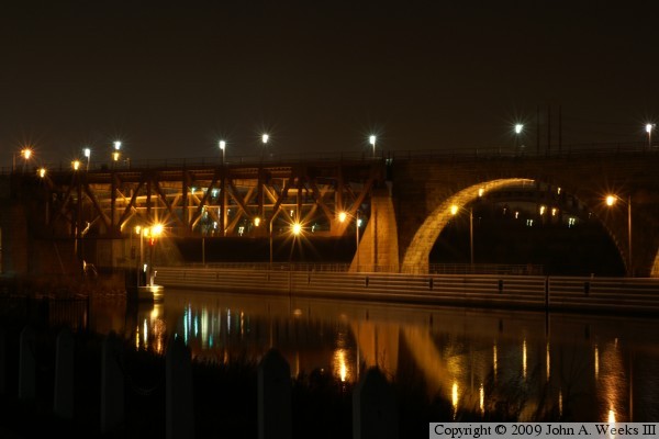
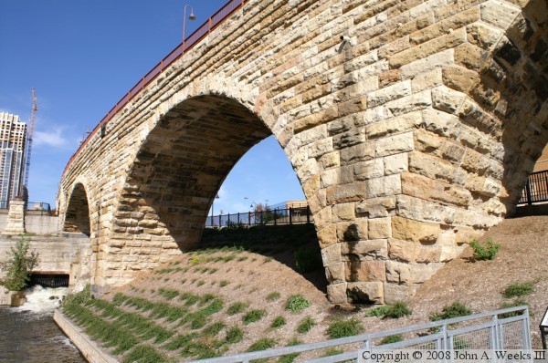
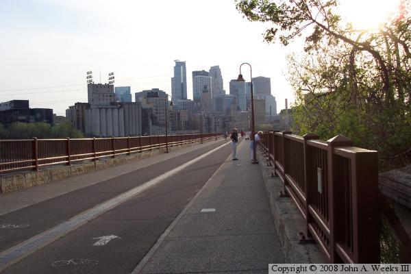
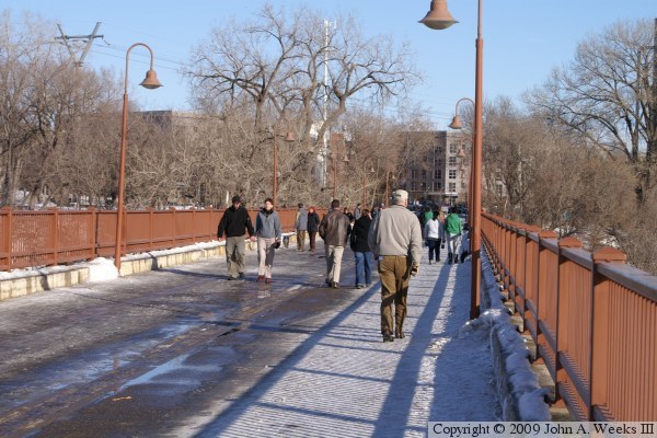
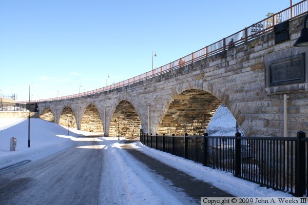
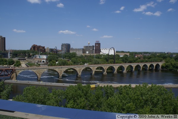
The Stone Arch Bridge sat unused through the 1980s and into the 1990s. A group of private and public organizations raised $2.5-million to refurbish the bridge for pedestrian traffic. The bridge reopened in 1994 after extensive repairs and the installation of a new deck and railings. Later, a decorative lighting systems was installed, and a decade later, lighting was installed under the bridge. The result is that this landmark structure is back in use, and it offers a spectacular view of the Saint Anthony Falls.

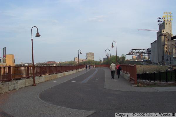
This bridge was a very popular location to view the aftermath of the I-35W bridge collapse in August, 2007. This bridge was the closest point for the viewing public during the first two weeks following the I-35W disaster. Police often closed the bridge during that time period when bodies were retrieved from the water to prevent people from taking photos of the recovery operation.

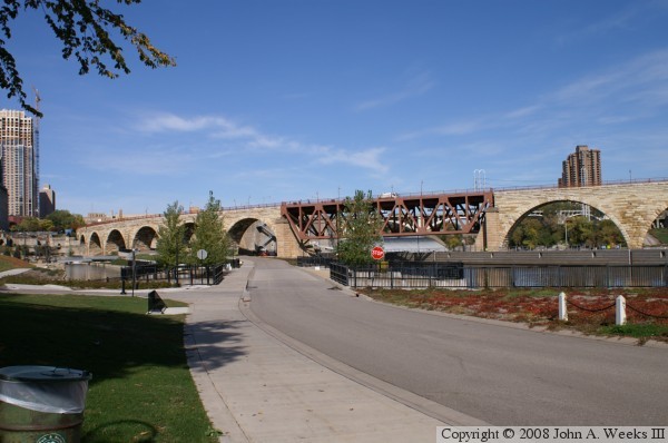
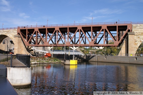
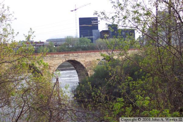
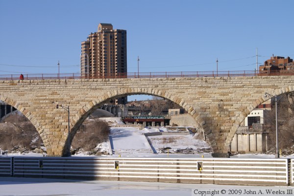
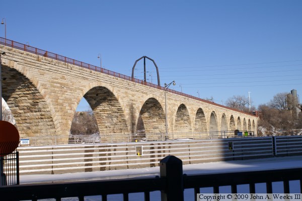
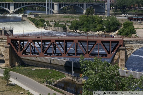
Two arches were removed in the 1960s to accommodate the construction of the lock and dam system that sits just upstream from the bridge. A steel truss was used to span the gap. This project reduced the number of arches from 23 down to 21. Since the bridge was an active rail line at that time, and Minneapolis was an important passenger hub, the bridge construction could not interrupt rail traffic. To accommodate this, the stone foundations where the bridge was to be cut were widened, and the steel truss was built outside of the stone. When the truss was ready, the stone arches were knocked out, and the rail lines were reinstalled on the truss section. Rail traffic was stopped for only 7 hours during the installation of the truss span.

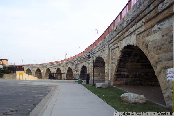
A massive flood struck the Twin Cities area in 1965. Two piers of the Stone Arch Bridge were undercut in the raging water, and one side of the bridge began to sag. The bridge was repaired and returned back to service. Evidence of the event is still visible where some of the rows of stones have a small sag on the south face of the bridge near the east end.

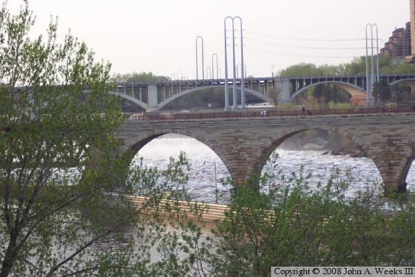
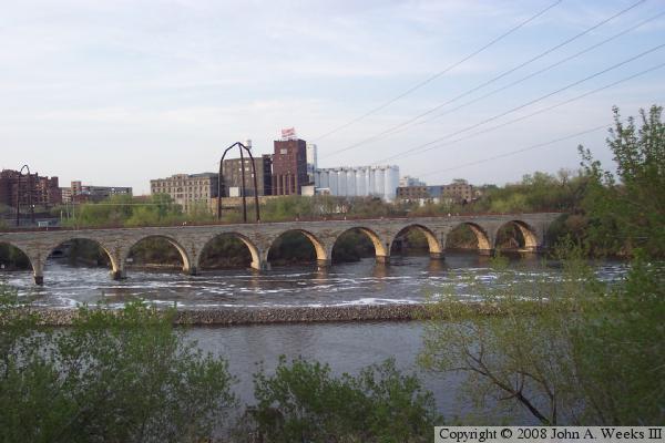
The photo at the top of the page is a little seen view of the Stone Arch Bridge. It is taken from the east river bank near water level from an old observation deck in Father Hennepin Park. The view is looking west across the river towards downtown. Since we are looking into the sun, and the stone is in the shadow, it appears darker. If you look closely, you can see smooth concrete blocks that have been installed to fill in for stones that have broken and fallen out of the structure. Another unusual aspect of this view is that we only see the straight part of the bridge, whereas most views from the west side of the river include the sweeping curve near the west bank of the river.


Stone Arch Bridge
The photo above is a view from a southbound traffic lane on the new I-35W Saint Anthony Falls Bridge. The view is looking upstream to the northwest towards the Saint Anthony Falls area. In addition to the Stone Arch Bridge, the Third Avenue and Father Louis Hennepin Bridges are visible in the background. The lower falls is obscured by the bridge railing, while the upper falls is obscured by the Stone Arch Bridge.

The photo below is a night view of the bridge span over the navigation channel.


Stone Arch Bridge
Stone Arch Bridge
The photo above is a view from Mill Ruins Park on the west side of the river. This view shows where the truss span over the lock channel fits into the overall bridge structure.

The photo below is a view of the eastern half of the Stone Arch Bridge as seen from the Mill Ruins Park.


Stone Arch Bridge
Stone Arch Bridge
The photo above is taken from the Upper Saint Anthony Falls Lock & Dam parking lot. The vantage point is near the north end of the bridge on the west side of the river. We see the bridge curve to the east before it crosses the river. Notice that the arch span over the roadway into the Lock & Dam is built a bit different from the other arches. It has a column of stone on each side of the arch, and the arch is one row of stones higher.

The photo below is the bridge plate located on the west end of the structure.


Stone Arch Bridge
Stone Arch Bridge
The photo above is a close view of the truss span over the navigation channel.

The photo below is a view of the Stone Arch Bridge as it starts to curve towards the river. The vantage point is in the Mill Ruins Park. Prior to the park being built, these sections of the bridge were covered with fill and mostly buried.


Stone Arch Bridge
Stone Arch Bridge
The photo above is the end of the bridge on the west bank of the river. The view is looking southeast. The Gold Medal Flower mill is on the far right of the photo. The metal truss near the flower mill is the trusswork for the Endless Bridge being built as part of the new Guthrie Theater.

The photo below is a view of the Stone Arch Bridge from the east end of the structure. The view is looking west towards downtown Minneapolis.


Stone Arch Bridge
Stone Arch Bridge
The photo above is a sign attached to the north end of the bridge identifying it as a landmark along the Saint Anthony Falls Heritage Trail.

The photo below is a view looking through the brush on the east side of the river. The building under construction on the west side of the river is the new Guthrie Theater. The Metrodome is visible to the left of the tower crane.


Stone Arch Bridge
Stone Arch Bridge
These two photo were taken looking through the trees along the West River Parkway just south of the bridge. In the photo above, we are looking north towards the main falls. The spectators on the bridge are watching the whitewater created as a high volume of water passes over the falls. The photo below is a view of the eastern half of the bridge in the evening. The setting sun is lighting up the area under the arches, but the front of the bridge is in the shadow. The former Pillsbury milling complex is located on the far side of the river.

Stone Arch Bridge
Stone Arch Bridge
The photo above is a view of the deck of the bridge on a chilly winter weekend afternoon. The Stone Arch Bridge is heavily used even in the deepest part of winter.

The photo below is a close view of one of the bridge arches. The Saint Anthony Falls Lab can be seen inside the arch, while the River Place condo tower towers over the bridge in the background.


Stone Arch Bridge
Stone Arch Bridge
These two photos are two more winter views of the Stone Arch Bridge. The photo above shows the series of arches that make up the main channel river crossing. The photo below is a view of the sweeping curve at the south end of the bridge.

Stone Arch Bridge
Stone Arch Bridge
These two photos are views of the Stone Arch Bridge as seen from the Endless Bridge at the Guthrie Theater. The walkway is a skydeck that is cantilevered out over the West River Parkway. It offers an amazing view of the falls area. The photo above is a close view of the deck truss span over the navigation channel. The photo below is the main channel crossing.

Stone Arch Bridge

Made With Macintosh
Authored by John A. Weeks III, Copyright © 1996—2016, all rights reserved.
For further information, contact: john@johnweeks.com