Current Weather Conditions
John A. Weeks III
Tuesday, April 16, 2024, 7:00:26 AM CDT
Home Photo Tours Rail Fan 12 Easy Steps
Aviation Spacecraft Highways & Bridges About The Author
 
Google Search
Maps   Groups   Images   Search
 
  Home
  • 12 Easy Steps
  • Aviation
  • Spacecraft
  • Highways & Bridges
    » Bridge Photography
      - MSP River Bridges
        › 10th Avenue Bridge
        › Arcola High Bridge
        › Betty Adkins Bridge
        › Bloomington Ferry
        › Bloomington Fry Tr
        › BNSF RR Bridge
        › Boom Island Foot Br
        › Broadway Avenue Br
        › C&NW Bridge (1)
        › C&NW Bridge (2)
        › Camden Bridge
        › Cedar Avenue Bridge
        › Cedar Ave Br (Old)
        › Cedar Ave Bicycle Br
        › Cedar Bend RR Br
        › Chaska Bridge (Old)
        › Chaska Swing Bridge
        › Chaska Trestle
        › Coon Rapids Dam
        › CP RR Bridge
        › Dan Patch Line Br
        › Dartmouth Bridge
        › East Channel Bridge
        › East Channel RR Br
        › East River Flats Br
        › Endless Bridge
        › F. W. Cappelen Mem
        › Father Henn Bluffs
        › Father Louis Henn Br
        › Ferry Street Bridge
        › First Avenue Bridge
        › Fort Road Bridge
        › Fort Snelling Br (Old)
        › Fort Snelling High Br
        › Great Western Bridge
        › Grey Cloud Channel
        › Grey Cloud Island Br
        › Grey Cloud Trail Br
        › Hastings High Bridge
        › Hastings Spiral Br
        › Holmes St Ped Bridge
        › Highway 243 Bridge
        › I-35W Bridge
        › I-35W Bridge (Old)
        › I-494 Bridge
        › I-694 Bridge
        › Interstate Bridge
        › Intercity Bridge
        › L St. Anthony F L&D
        › Lafayette Bridge
        › Lake Street Bridge
        › Lewis Street Bridge
        › Lexington Bridge
        › Lions Levee Pk Foot
        › Lock & Dam #1
        › Lock & Dam #2
        › Long Meadow Bridge
        › Lower Bridge
        › Lowry Bridge (Old)
        › Meeker Island L&D
        › Mendota Bridge
        › Merriam Street Br
        › Mill Ruins Park Br
        › Milwaukee Road Br
        › M&StL Bridge
        › Miss River Bridge 15
        › MN-101 Bridge
        › MN-41 Backchannel
        › MN-41 Back Ch (Old)
        › MN-41 Bridge
        › New Saint Croix Br
        › New Trunk-41 Bridge
        › Nicollet Island RR Br
        › North Miss Park Pier
        › NP Bridge #9
        › NP RR Bridge
        › Pike Island Bridge
        › Plymouth Bridge
        › Point Douglas DB
        › Raspberry Island Br
        › Richard P. Braun Br
        › Robert Street
        › Rock Island Swing Br
        › Runway 30 Light Br
        › Short Line Bridge
        › Smith Avenue High
        › Southeast Steam Plant
        › St. Anthony Falls Br
        › St. Anthony Falls Lab
        › St. Anthony Falls PP
        › St. Croix Boom Site
        › St. Croix Falls Dam
        › Stillwater Lift Br
        › Stone Arch Bridge
        › Third Avenue Bridge
        › Toll Bridge (Old)
        › U St. Anthony F L&D
        › US-8 Bridge
        › Wabasha Street Bridge
        › Wakota Bridge
        › Wakota Bridge (Old)
        › Walnut Street CW
        › Washington Ave Br
        › WI Central RR Br
        › WI Central RR Ruins
        › Wright Co Hwy 42
      - C & D Canal
      - Illinois River
      - Minnehaha Creek
      - Minnesota River
      - Mississippi River
      - Missouri River
      - St. Croix River
      - St. Louis River
      - Wisconsin River
      - Best Miss River Photos
      - Cable Stayed Bridges
      - McGilvray Road Bridges
      - I-35W Bridge Disaster
      - Miscellaneous Bridges
      - Madison County Bridges
      - Hist Br Weekend 2013
    » Road Geek Topics
  • Photo Tours
  • Rail Fan
  • About The Author
 
Site Search By JRank
Highways, Byways, And Bridge Photography
Raspberry Island Bridge
Raspberry Island Mississippi River Crossing
Saint Paul, MN

Raspberry Island Bridge

• Structure ID: NBI: 62580.
• Location: River Mile 839.51.
• River Elevation: 686 Feet.
• Highway: Service Road To Raspberry Island.
• Daily Traffic Count: 100 (2000).
• Bridge Type: Cast-In-Place Concrete.
• Length: 325 Feet Overall, 75 Foot Longest Span.
• Width: 1 Lane, 28 Feet.
• Navigation Channel Width: 70 Feet.
• Height Above Water: 20 Feet.
• Date Built: Opened November 2001.
Raspberry Island is the last true island in the Mississippi River in Saint Paul. There were more islands, including Harriet Island, but the small channels that flowed between these islands have been filled in. The island got its name in the 1880s due to the wild raspberries that grew along the shore of the river. The island was renamed Navy Island in 1948 after the establishment of a US Navy training facility. The Navy abandoned the island in the mid-1960s. From there, it became a parking lot for downtown workers. The island was renamed Raspberry Island with the planning of the new Wabasha Street Bridge in the early 1990s. A small band shell was erected, and a few concerts were put on over the years.

The west end of Raspberry Island is the home of the Minnesota Boat Club. They have used Raspberry Island since 1870, and the current boathouse dates back to 1910. Over the years, various nightclubs have used the 2nd floor of the boathouse. After a recent renovation, the 2nd floor is reserved for special events and weddings under an arrangement with the Saint Paul Radisson hotel.

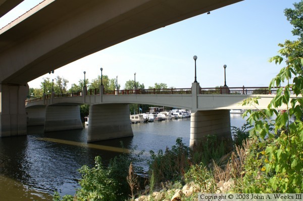
The old Raspberry Island bridge was in the way when the new Wabasha Street Bridge was built. To accommodate the construction, the old bridge was removed, and a temporary bridge was installed on the downstream end of the island. After the Wabasha Street Bridge was completed, a new 
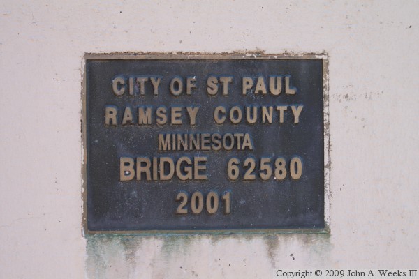
Raspberry Island bridge was built. That bridge was completed in 2001. At that time, the temporary bridge was removed.

Raspberry Island has seen a major renovation in 2007 and 2008. The old concrete walls were removed and riprap was installed around the island. This is to prevent erosion of the island. The island itself was totally landscaped. This included building a new bandstand, parking lot, public restrooms, and planting over 2500 trees and flowers.

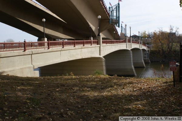
The photo above is a view of the downstream face of the Raspberry Island Bridge as seen from Raspberry Island. The photo below is a similar view of the upstream face of the bridge. The large structure above the bridge in these photos is the south end of the two parallel spans of the Wabasha Street Bridge.


Raspberry Island Bridge
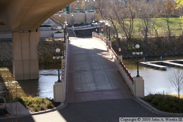
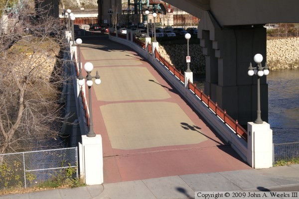
These two photos are views looking south from the stairway structure on the Wabasha Street Bridge. The bridge plaza is located on the far side of the river channel, with the Harriet Island Regional Park located to the west of the plaza.

Raspberry Island Bridge
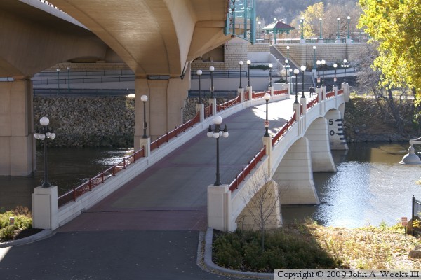
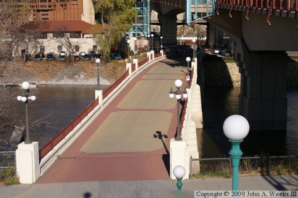
These two photos are views looking north towards Raspberry Island from the plaza located at the south end of the Wabasha Street Bridge. The Saint Paul Yacht Club is located on the west end of Raspberry Island, while the east end of the island is a city park. The park was redeveloped in the late 2000s with walking paths, a band shell, and a paved parking lot.

Raspberry Island Bridge
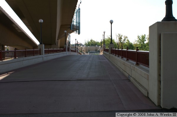
The photo above is a view of the Raspberry Island bridge from street level looking south down the length of the bridge deck towards the mainland. Much of the bridge is located under the Wabasha Street bridge, which casts a large shadow over the structure. The photo below is the bridge plate.

Raspberry Island Bridge

Made With Macintosh
Authored by John A. Weeks III, Copyright © 1996—2016, all rights reserved.
For further information, contact: john@johnweeks.com