Current Weather Conditions
John A. Weeks III
Saturday, April 20, 2024, 9:00:12 AM CDT
Home Photo Tours Rail Fan 12 Easy Steps
Aviation Spacecraft Highways & Bridges About The Author
 
Google Search
Maps   Groups   Images   Search
 
  Home
  • 12 Easy Steps
  • Aviation
  • Spacecraft
  • Highways & Bridges
    » Bridge Photography
      - MSP River Bridges
        › 10th Avenue Bridge
        › Arcola High Bridge
        › Betty Adkins Bridge
        › Bloomington Ferry
        › Bloomington Fry Tr
        › BNSF RR Bridge
        › Boom Island Foot Br
        › Broadway Avenue Br
        › C&NW Bridge (1)
        › C&NW Bridge (2)
        › Camden Bridge
        › Cedar Avenue Bridge
        › Cedar Ave Br (Old)
        › Cedar Ave Bicycle Br
        › Cedar Bend RR Br
        › Chaska Bridge (Old)
        › Chaska Swing Bridge
        › Chaska Trestle
        › Coon Rapids Dam
        › CP RR Bridge
        › Dan Patch Line Br
        › Dartmouth Bridge
        › East Channel Bridge
        › East Channel RR Br
        › East River Flats Br
        › Endless Bridge
        › F. W. Cappelen Mem
        › Father Henn Bluffs
        › Father Louis Henn Br
        › Ferry Street Bridge
        › First Avenue Bridge
        › Fort Road Bridge
        › Fort Snelling Br (Old)
        › Fort Snelling High Br
        › Great Western Bridge
        › Grey Cloud Channel
        › Grey Cloud Island Br
        › Grey Cloud Trail Br
        › Hastings High Bridge
        › Hastings Spiral Br
        › Holmes St Ped Bridge
        › Highway 243 Bridge
        › I-35W Bridge
        › I-35W Bridge (Old)
        › I-494 Bridge
        › I-694 Bridge
        › Interstate Bridge
        › Intercity Bridge
        › L St. Anthony F L&D
        › Lafayette Bridge
        › Lake Street Bridge
        › Lewis Street Bridge
        › Lexington Bridge
        › Lions Levee Pk Foot
        › Lock & Dam #1
        › Lock & Dam #2
        › Long Meadow Bridge
        › Lower Bridge
        › Lowry Bridge (Old)
        › Meeker Island L&D
        › Mendota Bridge
        › Merriam Street Br
        › Mill Ruins Park Br
        › Milwaukee Road Br
        › M&StL Bridge
        › Miss River Bridge 15
        › MN-101 Bridge
        › MN-41 Backchannel
        › MN-41 Back Ch (Old)
        › MN-41 Bridge
        › New Saint Croix Br
        › New Trunk-41 Bridge
        › Nicollet Island RR Br
        › North Miss Park Pier
        › NP Bridge #9
        › NP RR Bridge
        › Pike Island Bridge
        › Plymouth Bridge
        › Point Douglas DB
        › Raspberry Island Br
        › Richard P. Braun Br
        › Robert Street
        › Rock Island Swing Br
        › Runway 30 Light Br
        › Short Line Bridge
        › Smith Avenue High
        › Southeast Steam Plant
        › St. Anthony Falls Br
        › St. Anthony Falls Lab
        › St. Anthony Falls PP
        › St. Croix Boom Site
        › St. Croix Falls Dam
        › Stillwater Lift Br
        › Stone Arch Bridge
        › Third Avenue Bridge
        › Toll Bridge (Old)
        › U St. Anthony F L&D
        › US-8 Bridge
        › Wabasha Street Bridge
        › Wakota Bridge
        › Wakota Bridge (Old)
        › Walnut Street CW
        › Washington Ave Br
        › WI Central RR Br
        › WI Central RR Ruins
        › Wright Co Hwy 42
      - C & D Canal
      - Illinois River
      - Minnehaha Creek
      - Minnesota River
      - Mississippi River
      - Missouri River
      - St. Croix River
      - St. Louis River
      - Wisconsin River
      - Best Miss River Photos
      - Cable Stayed Bridges
      - McGilvray Road Bridges
      - I-35W Bridge Disaster
      - Miscellaneous Bridges
      - Madison County Bridges
      - Hist Br Weekend 2013
    » Road Geek Topics
  • Photo Tours
  • Rail Fan
  • About The Author
 
Site Search By JRank
Highways, Byways, And Bridge Photography
Nicollet Island Railroad Bridge
BNSF Railroad Mississippi River Crossing
Minneapolis, MN

BNSF Bridge

• Structure ID:
• Location: River Mile 854.5.
• River Elevation: 801 Feet.
• Railroad: Burlington Northern Santa Fe Railroad.
• Daily Traffic Count: 12 Trains Per Day (Estimated).
• Bridge Type: Plate Deck With Truss Section.
• Length: 550 Feet Overall, 171 Longest Span.
• Width: Two Tracks.
• Navigation Channel Width: 121 Feet.
• Height Above Water: 24 Feet.
• Date Built: Opened 1893.
The Saint Paul and Pacific Railroad built the first bridge across the Mississippi River in the Twin Cities area at this location. The bridge opened May 1, 1867. The complete river crossings consists of two spans, this bridge over the main channel of the Mississippi River, and one over the smaller east channel of the Mississippi River. The land between the two river channels is known as Nicollet Island.

The first bridge was an iron truss bridge, with the trains running through the truss span. That bridge was replaced in 1893 with a steel bridge that used the deck plate girder design. That bridge was rebuilt again in 1926. The bridge had to be modified in 1963 to support the 9-foot navigation channel project as the Upper and Lower Saint Anthony Falls Locks & Dams were set to open. Two deck plate spans and a pier were removed and replaced with a Petit style truss span. The bridge was modified once again in 1987 to accommodate the newly built West River Parkway, which passes under the west end of the bridge.

This bridge has gone through a number of owners since 1867. This includes the Saint Paul & Pacific, the Saint Paul, Minneapolis and Manitoba Railway, and later the Great Northern Railway. The Great Northern was part of a large merger to become the Burlington Northern, which merged once again to become the Burlington Northern Santa Fe. In addition to being used by a major railroad, several other railroads have trackage rights to this bridge. As a result, one does not need to wait long to see a train cross this structure.

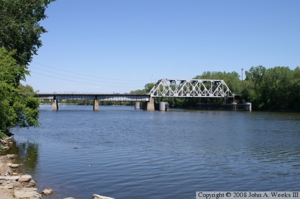
The photo above is a view of the Nicollet Island Railroad Bridge from a vantage point just downriver of the structure. Notice the large pilings and wooden guards that protect the bridge piers from barge strikes.

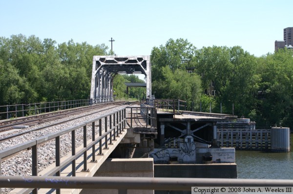
The photo below was taken from the parking lot located at the very west end of the bridge. An interesting feature of the bridge is that a spur rail line once diverged from the bridge at the midpoint of the river crossing. I have not been able to document when that spur was built, or when it was removed. This spur line allowed trains to have access to the Minneapolis Union Depot, which was located at the site of the current downtown Minneapolis post office, and later, the Great Northern Depot, which was located on the site of the new Federal Reserve building. The Great Northern Depot was demolished in 1978, which leads the author to suspect that the rail spur was removed when the West River Parkway was built in 1986.


BNSF Bridge
BNSF Bridge
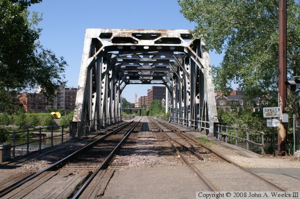
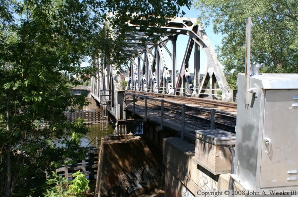
The photo above is a view of the northern bridge portal on Nicollet Island. The Warehouse District just west of downtown Minneapolis is located on the far side of the river. The photo below is a slightly different view of the bridge from Nicollet Island.

BNSF Bridge
BNSF Bridge
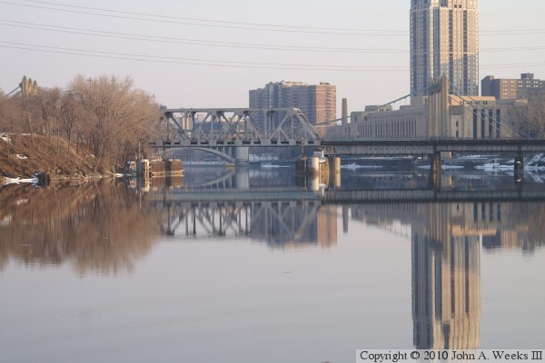
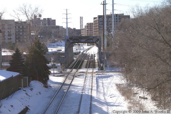
These two photos are winter views of the Nicollet Island Railroad Bridge. The photo above is from a later March afternoon in 2010. The river is almost glass smooth making for some excellent reflections. This view is looking east from Boom Island. The photo below is a view of the bridge on a very cold winter morning in 2009 as seen from a highway overpass located on Nicollet Island.

BNSF Bridge
BNSF Bridge
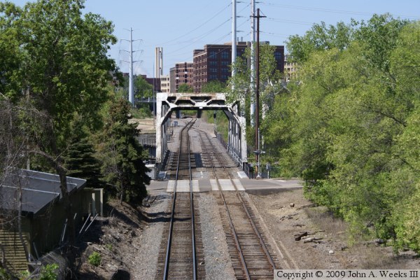
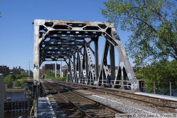
These two photos are from the early summer of 2009, whereas the similar photos above were shot in 2005. While the bridge site looks very much the same, there have been changes over the recent years. In the photo above, we see the that one of the parallel tracks has been removed south of the bridge, and the main line crosses from the left side of the right-of-way to the right side. In the photo below, we see that the short bridge segment between the truss span and Nicollet Island, which was a steel girder bridge, has been replaced with a concrete girder span.

BNSF Bridge
BNSF Bridge
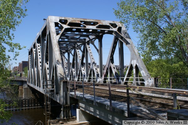
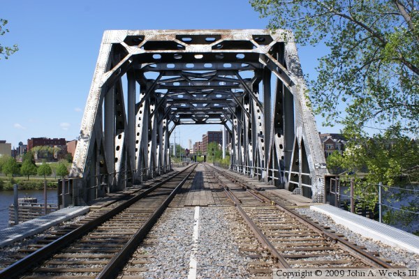
These two photos are also from early summer of 2009. Both photos are looking southwest across the main channel span of the Nicollet Island Railroad Bridge. In the photo above, we see that the guard rails, which where located between the two rails of the track on the left, have been removed, while part of the guard rails on the right side track has also been removed. The old brown ballast has been replaced with fresh white ballast. A concrete rib that is part of the new concrete bridge segment can be seen running between the two sets of tracks. Finally, new walkways have been installed on the edges of the first bridge segment.

BNSF Bridge
BNSF Bridge
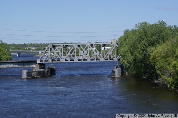
These two photos are views of the Nicollet Island Railroad Bridge as seen from the nearby Father Louis Hennepin suspension bridge, located 950 feet downstream. The photo above is an overview of the entire river crossing, while the photo below is a close view of the navigation channel span.

BNSF Bridge

Made With Macintosh
Authored by John A. Weeks III, Copyright © 1996—2016, all rights reserved.
For further information, contact: john@johnweeks.com